What is LIDAR landscape scanning?
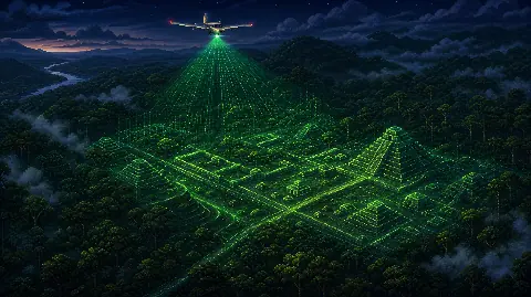
LIDAR stands for light detection and ranging. A plane, helicopter, drone, or ground system sends out rapid laser pulses and measures how long those pulses take to return. The result is a dense set of elevation points that can be processed into a terrain model.
In archaeology, the most dramatic use is canopy penetration. Some laser returns bounce off leaves and branches, while others reach the ground. By filtering the data, researchers can model the land surface beneath vegetation.
The important point is simple: LIDAR is not a photograph of the past. It is a precise map of landform and surface variation. Interpretation still needs archaeology.
What can LIDAR reveal?
LIDAR is powerful because ancient people often changed landscapes in ways that remain visible after buildings decay. Raised roads, platforms, defensive earthworks, field systems, reservoirs, canals, and terraces can survive as subtle height changes.
| Feature | What LIDAR may show | What still needs checking |
|---|---|---|
| Roads and causeways | Raised or linear landforms | Ground survey and dating |
| Terraces | Stepped slopes or field edges | Soil study and agricultural context |
| Platforms | Regular elevated shapes | Excavation and cultural comparison |
| Water systems | Channels, reservoirs, or embankments | Hydrology and use history |
This is why LIDAR has become so important for rainforest archaeology and large landscape surveys. It can show that a region was organised at a scale that ordinary walking surveys may miss.
How should you read LIDAR archaeology claims?
Read LIDAR stories in layers. First ask what the scan detected. Then ask whether specialists have confirmed it on the ground. Finally, ask what dating evidence links the feature to a particular culture or period.
- Detection: the scan shows a possible feature.
- Verification: fieldwork confirms that the feature is real and not a processing artefact.
- Dating: pottery, charcoal, stratigraphy, or other evidence places it in time.
- Interpretation: researchers connect it to settlement, ritual, agriculture, defence, or movement.
That sequence keeps the discovery exciting without turning every shaded relief image into a finished historical claim.
A scan can reveal that a landscape was more organised than expected. It cannot, by itself, tell you who built it.
Why does LIDAR matter to ancient alien theory?
Ancient alien theory often starts from a claim that ancient people could not have built something. LIDAR complicates that claim in a useful way. It can reveal huge, complex systems, but those systems usually make human societies look more capable, not less.
A newly mapped city, road network, or water system may feel impossible at first glance because the surface view hid most of the evidence. Once the wider landscape is visible, the achievement often becomes more understandable. It shows planning, labour, adaptation, and long-term local knowledge.
That makes LIDAR both exciting and sobering. It expands the ancient world without needing to remove human agency from it.
Where can LIDAR mislead readers?
The biggest risk is over-reading shapes. Shaded terrain models can make ordinary erosion, modern disturbance, tree falls, or data noise look intentional. Once an image spreads online, viewers may start seeing grids, faces, landing strips, star maps, or impossible ruins before specialists have tested the site.
Good LIDAR interpretation depends on multiple lines of evidence. A clean-looking shape is a starting point, not a conclusion.
- Check whether the image is a peer-reviewed study, press release, documentary graphic, or social media crop.
- Look for field confirmation rather than relying only on digital models.
- Ask whether the feature matches known regional building patterns.
- Be cautious with claims that jump straight from "hidden" to "alien".
Is LIDAR proof of lost advanced civilisations?
LIDAR can support evidence for lost or under-recognised societies, but it does not prove a technologically advanced civilisation in the ancient alien sense. Most discoveries are better understood as evidence of human settlement, land management, farming, engineering, and social organisation.
The method can still change history. It may reveal that a region supported more people than scholars expected, or that ancient infrastructure was larger and more connected than the ground view suggested. That is already significant without adding off-world builders.
Best use in the archive
Use this page as a methods guide for lost city stories, pyramid landscapes, alignment claims, earthworks, and hidden infrastructure. It belongs beside source checks because it helps separate a real discovery from the story later built around it.
The lesson is not that every scan hides an impossible civilisation. The better lesson is that the past is often larger than the surface view.
FAQs
What does LIDAR mean?
LIDAR means light detection and ranging. It uses laser pulses to measure distance and create detailed 3D information about surfaces.
Can LIDAR see through trees?
LIDAR does not literally see through solid trees, but some laser pulses pass through gaps in the canopy and reach the ground. Filtering those returns can reveal terrain below vegetation.
Does LIDAR prove ancient aliens built lost cities?
No. LIDAR can reveal hidden archaeology, but the builder and meaning of a site require fieldwork, dating, and cultural context.
Why is LIDAR important for archaeology?
It lets researchers study large landscapes quickly and detect subtle features that might be difficult to see from the ground.